Current extent and trends of agroforestry in the EU27
This report (updated in August 2016) is an output from work-package 1 which aims to understand the context and extent of agroforestry in Europe. In an earlier report, den Herder et al (2015) reviewed literature sources to provide a preliminary estimate of the extent of agroforestry in Europe. That report (which collected only limited data from some countries) estimated that agroforestry extends to at least 10.6 million hectares in Europe. By contrast the CORINE land cover survey gives an “agroforestry” classification to 3.3 million ha in Europe. This is substantially less than the value reported by den Herder et al (2015) and is the result of CORINE having a very narrow definition of agroforestry. It is apparent that a more harmonized and uniform pan-European estimate is needed.
In this report, the agroforestry areas of Europe were primarily mapped using LUCAS Land Use and Land Cover data. The Copernicus Land Monitoring Survey (high resolution maps with tree cover density) was also used to estimate tree cover on agricultural land in seven countries (Austria, Switzerland, Estonia, Latvia, Lithuania, Sweden and Norway). Both sets of results were compared with a review of the literature and statistical inventories.
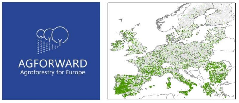
Using the LUCAS database the total area under agroforestry in the EU27 is estimated to be 15.4 million ha which is equivalent to 3.6% of the territorial area or 8.8% of the utilised agricultural area. This is a larger estimate than the 10.6 million ha reported in the literature review. Livestock agroforestry is, by far, the dominant type of agroforestry in Europe accounting for 15.1 million ha. The area of silvoarable systems is estimated to be 358 thousand ha. The above totals include the grazing and intercropping of permanent crops (e.g. fruit trees and olives) (1.05 million ha) comprising 0.85 million ha of grazed systems and 0.22 million ha of intercropped systems. A hot spot analysis revealed that a high abundance of areas under agroforestry can be found in south, central and north-east Portugal, south-west, central and parts of north Spain, south of France, Sardinia, south Italy, central and north-east Greece, central and west Bulgaria, and an area in northern Romania.
LUCAS data were also used to estimate the extent of single trees and green linear elements such as hedgerows. Agroforestry involving single trees covers almost 300 thousand hectares corresponding to around 0.02% of the territorial area in the EU, with high values in France, Spain, the UK, and Italy. Agroforestry involving hedgerows cover about 1.78 million hectares representing around 0.42% of the territorial area in the EU, with large values in France, the UK, and Italy.
The higher estimate for the agroforestry area using the LUCAS data (15.4 million ha) than the literature review (10.6 million ha) can be partly explained by the inclusion of Bulgaria (+0.87 million ha) and higher estimates for Spain (+1.74 million ha), France (+1.05 million ha), Romania (+0.71 million ha), Italy (+0.44 million ha), the UK (+0.39 million ha), and Sweden (+0.37 million ha); there were lower estimates for Greece (-0.67 million ha) and Portugal (-0.48 million ha). When the LUCAS estimates were compared with national inventories, the LUCAS-based estimate of 5.58 million ha of agroforestry in Spain was within 10% of a national inventory value of 6.14 million ha. However the LUCAS estimate for Portugal (1.17 million ha) was 22% lower than an estimate based on national inventories.
Although there may still be some systematic errors, because the LUCAS data were collected and analysed in a uniform manner, it provides a method to compare agroforestry areas between countries and regions. It can highlight where agroforestry is currently practiced and where there are opportunities. Considering the fact that agroforestry covers about 9% of the utilised agricultural area of the EU, agroforestry deserves a more prominent place on policy agendas.
den Herder, M., Moreno, G., Mosquera-Losada, M.R., Palma, J.H.N., Sidiropoulou, A., Santiago Freijanes, J.J., Crous-Duran, J., Paulo, J., Tomé, M., Pantera, A., Papanastasis, V., Mantzanas, K., Pachana, P., Papadopoulos, A., Plieninger, T., Burgess, P.J. (2016). Current extent and trends of agroforestry in the EU27. Deliverable Report 1.2 for EU FP7 Research Project: AGFORWARD 613520. (15 August 2016). 2nd Edition. 76 pp.
Note: the values in the August 2016 version have been revised from the December 2015 version. For example areas of wood pasture are only included where there is evidence of grazing, and olive groves with inter-row cultivation are only included if an intercrop is grown.
The main report contains annexes related to Spain, Portugal and Greece. Below is a separate annex which describes the extent and trends of agroforestry in France.
Malignier, N., Balaguer, F. (2017). Annex to Deliverable 1.2: Current extent and trends of agroforestry in France. AGFORWARD 613520. (7 February 2017). 10 pp.